I Love To Go A Gardening
Growing Our Life in Northern Michigan
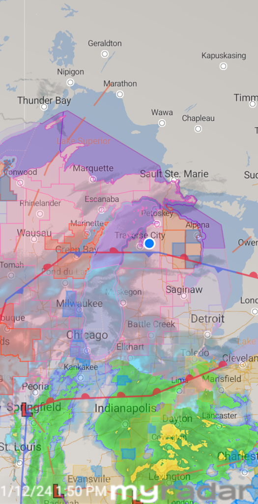
Storm Watch
We have had a mild winter with very little snow, most of which melted not long after it fell. However, apparently that is about to end. Meteorologists are issuing Storm and/or Blizzard Warnings beginning sometime today and lasting until Saturday evening.
I’m not sure how much snow we will get. We seem to be on a border of either getting 9-13 inches of snow or 18 inches. We will also likely get lake-effect snow. Unlike snow that comes in with a storm system, Lake-effect snow is produced during cooler atmospheric conditions when a cold air mass moves across long expanses of warmer lake water. The lower layer of air, heated by the lake water, picks up water vapor from the lake and rises through colder air. The vapor then freezes and is deposited on the leeward (downwind) shores. (Wikipedia)
The snow isn’t a horrible problem because we live in the North where we get snow every winter so the counties have good snow plows. The wind is the greater hazard. We could get strong winds gusting as high as 55 mph, which can blow the snow around and reduce visibility. That is particularly dangerous for motorists. The strong wind can also blow down trees and cause power outages.
EJ has tomorrow off. Once he gets home, we will just hunker down together. We have a propane heater so we will stay warm if we lose power. I’m making a big pot of chili.
My greatest concern is for our son, who is currently on his Great Lakes bulk carrier traveling from Lake Erie, through Lakes Huron and Michigan to Chicago. Several crew members on the ship are sick, including him. He’s stuck in his room on the ship feeling pretty miserable, he says. That’s bad enough, but there are Gale Warnings out for the Lakes until about Sunday morning (depending on the lake). The forecasted conditions for Erie and Michigan are similar, projecting winds to be 35 to 45 knots with gusts up to 55 knots and waves 13 to 18 feet. In northern Lake Huron the forecast is for sustained winds up to 41 knots with gusts up to 52 knots. The largest significant waves will be 22 feet with a potential maximum wave height of 32 feet. That’s a nasty storm that can damage ships or cause them to capsize. JJ says that the largest waves he has ever experienced were about 8-9 feet.
Fortunately, JJ’s ship won’t be traveling through Lake Superior, where forecasts say heavy freezing spray at a rate of 2 cm (.78 inches) per hour or greater is expected, and may rapidly accumulate on vessels, which is extremely hazardous. Freezing spray can cause mechanical and electronic components to become inoperative. Rapid ice formation on decks and superstructures can result in a catastrophic loss of stability.
I track ships using a marine traffic app. It appears that most ships are going to safe ports, but JJ’s ship is apparently determined to continue its course through the storm. I’ll continue to track his ship, watch for his ship to pass by YouTube live stream cams, and pray for his and his ship’s safety. There are a lot of people praying as well.
Here is a map of storm warnings for the Great Lakes area.